You probably used GPS today without thinking about it. You may have used it to navigate to work, order food, book a cab, track a delivery, exercise, make a payment, or simply check where you were. But GPS was never designed for any of those things.
It was designed for something much more serious:
knowing exactly where you were – and exactly what time it was – anywhere on Earth.
The Global Positioning System began as a U.S. military project during the Cold War.
Today, it is part of the invisible infrastructure of modern civilization.
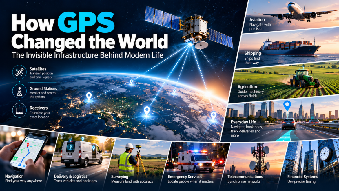
It helps aircraft navigate.
Ships find their way.
Farmers guide machinery across fields.
Surveyors measure land.
Telecommunications networks synchronize equipment.
Financial systems use precise timing.
Emergency services locate people.
Smartphones turn satellite signals into directions.
Ride-hailing companies coordinate drivers and passengers.
Delivery companies track vehicles.
And billions of people use location services without ever thinking about the satellites overhead.
The remarkable story of GPS is therefore not simply the story of a navigation system.
It is the story of how precision became infrastructure.
Before GPS, knowing where you were was surprisingly difficult
Humans have navigated for thousands of years.
We used:
- Stars
- Compasses
- Maps
- Landmarks
- Radio beacons
- Dead reckoning
- Celestial navigation
These methods could be remarkably sophisticated.
But they had limitations.
A ship couldn’t simply ask:
“Where am I?”
and receive an answer accurate enough to locate itself automatically.
An aircraft couldn’t simply calculate its precise position using signals from space.
A farmer couldn’t guide machinery to a precise location using a satellite constellation.
What the world needed was a global reference system.
And the key insight was surprisingly elegant:
Don’t try to determine where you are by measuring the Earth. Put clocks in space and let the signals tell you.
The idea began with satellites and clocks
The foundations of GPS emerged from several U.S. military navigation projects.
The U.S. Department of Defense eventually consolidated these efforts into a joint system.
In 1973, the Air Force was assigned responsibility for developing and deploying what became known as the NAVSTAR GPS system.
The core architecture depended on something humans had been trying to perfect for centuries:
timekeeping.
GPS satellites carry extremely precise clocks.
They continuously transmit signals containing information about their position and time.
A receiver on Earth receives those signals.
Because radio signals travel at a known speed, the receiver can calculate how long the signals took to arrive.
From those timing differences, it can determine its position.
GPS.gov describes the system as providing positioning, navigation and timing services, with satellites transmitting signals containing their position and time.
In other words:
GPS is fundamentally a giant timing system.
The map is only what we see on top of it.
The first GPS satellite went into space in 1978
On February 22, 1978, NAVSTAR 1 was launched from Vandenberg Air Force Base in California.
Three additional developmental satellites followed that year.
The system was still experimental.
The engineers were proving that space-based navigation could work.
The early satellites were not yet the global utility that billions of people would eventually depend upon.
But the architecture was taking shape.
A constellation of satellites would provide overlapping signals.
Ground stations would monitor and control them.
Receivers would calculate their position.
The basic system would eventually consist of three major segments:
Space segment – satellites
Control segment – ground stations
User segment – receivers
That architecture still defines GPS today.
Why atomic clocks mattered
GPS works because time matters enormously.
Imagine a radio signal traveling at approximately the speed of light.
If your measurement of its travel time is slightly wrong, your calculated distance from the satellite will also be wrong.
A tiny timing error can translate into a significant positioning error.
That’s why GPS relies on extremely precise clocks.
The early development program experimented with atomic clocks in space. The NTS-1 satellite launched in 1974 carried the first atomic clock into orbit, and later experiments helped establish the timing technology used in GPS.
This leads to an important insight:
GPS is not primarily a “location technology.”
It is a time-and-location technology.
And that distinction becomes extremely important later.
The system wasn’t built for smartphones
The original motivation was military.
The U.S. military needed reliable positioning and navigation for aircraft, ships, vehicles and weapons.
GPS became especially important during military operations because forces operating over large and unfamiliar areas needed accurate positioning.
The U.S. Space Force notes that GPS was heavily used during Operations Desert Shield and Desert Storm, including navigation across the featureless Arabian Desert.
The technology offered something extraordinarily valuable to military planners:
A common global reference system.
Different units could know where they were.
Aircraft could navigate.
Weapons could use precise coordinates.
Vehicles could coordinate movement.
The battlefield itself became increasingly digital.
Then GPS became available to civilians – with a catch
The U.S. government eventually made GPS available for civilian use.
But civilian users did not initially receive the same level of accuracy available to the military.
During the 1990s, the U.S. government deliberately degraded the accuracy of civilian GPS signals through a feature called Selective Availability.
The reason was national security.
Civilian users could use GPS.
But the system was intentionally less precise.
GPS.gov records that Selective Availability could cause civilian readings to be inaccurate by as much as roughly 100 meters.
That limitation would have enormous consequences for the civilian technology industry.
Because the real GPS revolution had not yet begun.
Then, on May 1, 2000, something changed
President Bill Clinton directed the U.S. government to discontinue Selective Availability.
The decision dramatically improved civilian GPS performance.
The U.S. Department of Commerce said at the time that the move could make GPS far more accessible to commercial, scientific and government users around the world.
The predicted civilian error improved from approximately 100 meters to around 20 meters, with real-world performance often better depending on circumstances.
GPS.gov now describes the removal of Selective Availability as a moment that unleashed a worldwide revolution in civil and commercial applications.
That decision deserves far more attention than it usually receives.
Because it helped turn GPS from a useful government technology into a foundation for an enormous commercial ecosystem.
Suddenly, businesses could build around location
Once civilian GPS became more accurate and accessible, entrepreneurs had a powerful new capability.
A device could determine:
Where am I?
And increasingly:
Where am I moving?
How fast am I moving?
Where have I been?
Where is another object?
That opened the door to entirely new applications.
Fleet management.
Navigation.
Asset tracking.
Precision agriculture.
Surveying.
Logistics.
Emergency response.
Outdoor recreation.
Location-based advertising.
Ride-hailing.
Food delivery.
Fitness tracking.
And eventually, smartphone location services.
The smartphone turned GPS into a consumer experience
The first GPS receivers were specialized devices.
You might buy one for navigation, aviation, surveying or marine use.
Then GPS receivers became smaller and cheaper.
Eventually, they became components inside smartphones.
That was the moment GPS became almost invisible.
A user no longer thought:
“I am using a satellite navigation system.”
They thought:
“Google Maps says turn left.”
The complexity disappeared.
That is often the final stage of infrastructure.
People stop noticing the technology.
GPS changed the meaning of a map
Traditional maps answer:
Where are things?
GPS-enabled maps can answer:
Where am I?
That difference is enormous.
A paper map requires you to identify yourself within the map.
GPS-enabled navigation identifies you automatically.
The map becomes dynamic.
Your position moves.
The route changes.
Traffic information can be incorporated.
Estimated arrival time changes.
Nearby businesses appear.
The map becomes a real-time interface between the physical world and digital information.
Then GPS became a business platform
Once devices could determine location, companies could build services around it.
Consider ride-hailing.
A ride-hailing application needs to know:
Where is the passenger?
Where are available drivers?
How far apart are they?
What route should the driver take?
How long will the journey take?
GPS doesn’t create the ride-hailing business.
But without location infrastructure, the experience would be dramatically harder.
The same is true for food delivery.
A delivery platform needs to coordinate:
Restaurant → Driver → Customer
Location data becomes the invisible coordination layer.
Logistics became smarter
GPS also transformed fleet management.
A company operating hundreds or thousands of vehicles can know:
- Where vehicles are
- How they are moving
- Whether they are following routes
- How long deliveries take
- Where delays occur
- When vehicles need maintenance
That turns transportation into a data system.
The physical fleet becomes measurable.
And once something becomes measurable, it can increasingly be optimized.
This is one of the recurring patterns of digital transformation:
Sensors create data. Data creates visibility. Visibility creates optimization.
GPS was one of the technologies that helped make this possible at planetary scale.
Agriculture became more precise
GPS also helped create precision agriculture.
Instead of treating an entire field as one uniform area, farmers can use precise location information to guide machinery and manage operations more accurately.
GPS.gov identifies agriculture among the industries that benefit from GPS and notes that higher-accuracy applications can use augmentation technologies when basic GPS is not sufficient.
This can support:
- Automated guidance
- Field mapping
- Precise planting
- Fertilizer application
- Yield mapping
- Machine coordination
The result is another example of the same pattern:
A military technology becomes commercial infrastructure.
Surveying became dramatically more powerful
Surveyors historically relied on complex measurement techniques.
Modern high-precision positioning systems can achieve dramatically greater accuracy than ordinary consumer GPS.
GPS.gov notes that augmentation systems and advanced receivers can enable positioning at centimeter-level accuracy for high-end applications, with long-term measurements reaching millimeter levels in some specialized contexts.
That matters for:
- Construction
- Mapping
- Infrastructure
- Mining
- Engineering
- Land management
Again, GPS isn’t merely telling someone where they are.
It is allowing professionals to measure the physical world.
GPS became a clock for the modern economy
This may be the least visible and most important part of the story.
GPS isn’t just used for positioning.
It is also used for timing.
GPS.gov states that GPS time transfer is commonly used to synchronize clocks and networks to Coordinated Universal Time, with specialized receivers able to transfer time with very high precision.
Why does that matter?
Modern systems depend on synchronized time.
Telecommunications networks.
Power infrastructure.
Financial systems.
Data networks.
Scientific systems.
Industrial systems.
If different systems don’t agree about time, coordinating events becomes much harder.
GPS therefore became a kind of invisible global clock.
You may never see the satellites.
But their timing signals can influence systems on Earth.
The GPS revolution was bigger than navigation
This is the point where the story becomes fascinating.
When most people hear “GPS,” they think:
Directions.
But the technology really provides three capabilities:
Position
Navigation
Timing
The first two are visible.
The third is largely invisible.
And the invisible part may be just as important.
The business model was unusual
GPS is an unusual example of infrastructure because the basic civilian positioning service is provided free of direct user charges.
GPS.gov describes GPS as a U.S.-owned utility whose free, open and dependable nature has contributed to hundreds of applications.
That creates a fascinating economic structure.
The government funds and maintains the infrastructure.
Companies build receivers and software.
Entrepreneurs build services.
Consumers purchase devices and services that depend on GPS.
The value is therefore captured above the infrastructure layer.
This is an important business lesson.
Sometimes the biggest economic impact of a technology isn’t created by charging users for the underlying technology.
It comes from allowing an ecosystem to build on top of it.
Free infrastructure can create enormous markets
Consider what happened after GPS became broadly usable.
Nobody had to buy a “GPS subscription” before Uber could exist.
Nobody had to pay the government every time Google Maps calculated a route.
A logistics company didn’t need to negotiate a satellite contract before installing tracking devices.
The underlying capability became infrastructure.
Businesses competed to build products around it.
That is one reason infrastructure technologies can be so transformative.
They lower the cost of experimentation.
GPS helped create location as a new form of data
Before ubiquitous digital location services, location was relatively static.
A person’s location might be:
Home address
Office address
Postal address
GPS made location dynamic.
Now a system could know:
Where you are right now.
That created an entirely new category of data.
Location could be combined with:
- Time
- Search
- Purchases
- Movement
- Weather
- Traffic
- Photos
- Social activity
This created powerful applications.
It also created serious privacy questions.
The privacy problem arrived with the opportunity
The same technology that makes navigation convenient can reveal movement patterns.
A location history can potentially tell us:
- Where someone lives
- Where they work
- Where they travel
- Which places they visit
- How long they stay
That makes location data unusually sensitive.
GPS itself doesn’t necessarily know who you are.
But applications using location signals can combine them with identity and behavioral information.
The technology therefore created a new tension:
Convenience vs. privacy
And that tension has become increasingly important as location-based services have expanded.
GPS also changed advertising
Location created another opportunity:
contextual relevance based on physical proximity.
A restaurant might want to reach customers nearby.
A retailer might want to promote a store.
A travel company might want to reach visitors.
A navigation application might recommend businesses along a route.
This created a new dimension of marketing:
Where are you?
Traditional advertising often asks:
Who are you?
Digital advertising added:
What are you interested in?
Location-based services added:
Where are you right now?
That can be extraordinarily powerful.
But GPS is not magic
There is an important misconception worth correcting.
GPS isn’t always perfectly accurate.
GPS.gov notes that consumer smartphone positioning is typically accurate to within about 4.9 meters under open sky, but accuracy can deteriorate around buildings, bridges, trees and other obstructions.
Problems can arise from:
- Signal blockage
- Reflections
- Atmospheric conditions
- Satellite geometry
- Receiver quality
- Interference
That is why your phone occasionally thinks you’re on the wrong side of a building.
The satellites may be functioning perfectly.
The problem may be the environment between you and them.
GPS became one member of a much larger family
GPS is now part of the broader world of Global Navigation Satellite Systems – GNSS.
Other systems include:
- Galileo
- GLONASS
- BeiDou
Modern devices can often use signals from multiple systems.
That can improve availability and positioning performance.
But GPS remains one of the foundational systems around which the modern location ecosystem developed.
From satellites to AI
The next evolution is already underway.
GPS provides a fundamental signal:
Where are you?
AI can add another layer:
What does that location mean?
Imagine a system that knows:
- Where you are
- Where you’re going
- What you’re likely to need
- What traffic conditions exist
- What businesses are nearby
- What your calendar says
- What your preferences are
Location becomes more than a coordinate.
It becomes context.
This is where GPS could become even more valuable in the AI era.
The satellite system provides the raw spatial reference.
Software turns it into information.
AI can potentially turn that information into decisions.
What entrepreneurs can learn from GPS
1. Infrastructure creates opportunity
The biggest businesses often emerge on top of capabilities they didn’t have to invent.
2. Free can be strategically powerful
When infrastructure is broadly accessible, the ecosystem built on top can become enormous.
3. Solve a fundamental problem
GPS answers a deceptively simple question:
Where am I?
Fundamental problems can support enormous ecosystems.
4. Don’t focus only on the visible use case
Navigation is obvious.
Timing is less obvious.
Yet timing may be just as important.
5. Precision creates economic value
Knowing something approximately can be useful.
Knowing it precisely can create entirely new businesses.
6. Infrastructure becomes most powerful when it disappears
The best infrastructure doesn’t demand attention.
It simply works underneath everything else.
The invisible technology we stopped noticing
GPS may be one of the strangest technology success stories in modern history.
A system developed for military navigation became a foundation for civilian life.
A constellation of satellites became a smartphone feature.
A military positioning technology became a commercial platform.
A navigation system became a timing infrastructure.
A government-funded capability enabled thousands of private businesses to create products and services.
And eventually, billions of people stopped thinking about it.
That may be the clearest sign of technological success.
We don’t marvel at GPS every time Google Maps gives us directions.
We simply expect it to work.
We expect our phone to know where we are.
We expect the map to follow us.
We expect the delivery driver to find our address.
We expect the taxi to find us.
We expect the workout application to know how far we’ve run.
We expect the aircraft to know where it is.
We expect networks to keep time.
Those expectations were not always normal.
They were created by infrastructure.
The bigger lesson
The history of GPS teaches us something important about innovation.
The most transformative technologies don’t always arrive as consumer products.
Sometimes they begin as enormous infrastructure projects.
They may be built for governments.
They may be too expensive for ordinary people.
They may look irrelevant to entrepreneurs.
And then, one day, the underlying capability becomes cheap, accessible and reliable enough for millions of people to build on top of it.
That is when the real revolution begins.
GPS didn’t become transformative because people wanted better maps.
It became transformative because the world suddenly had a reliable digital reference for location and time.
Everything else came afterward.
The navigation app.
The ride-hailing service.
The delivery tracker.
The fitness watch.
The precision farmer.
The surveying system.
The location-based advertisement.
The synchronized network.
They are all different expressions of the same underlying idea.
Know where you are. Know when you are. Then build something on top of that knowledge.
And that is why GPS may be one of the most important pieces of invisible infrastructure ever created.